The Department of Transport has asked for comments on its Active Travel Delivery Plan which will be realised over the next 20 years. The consultation closes on February 28, 2025.
This is the first of a two-part blog. We urge you to comment on the consultation and point out the short-comings of the plan in your local area. Feel free to use (copy/paste) all or part of our local analysis in this blog instalment. DfI's ATDP will shape our borough's Active Travel infrastructure for the next generation. If you have children, please invest the time it takes to complete the online consultation, make sure that your voice is heard and your opinion is taken on board!
Next week's instalment will cover the nitty-gritty of what is actually necessary to deliver the plan, something that is not included in the present version of the delivery plan.
The consultation document focuses on three areas:
1. Connections to local schools
2. Connections to public transport
3. Connections to town centres
Ideally the connections would use a hub-and-spoke arrangement, like a bicycle wheel to connect local amenities and residential areas. When our cycle campaign group's committee looked at the plans proposed for Ards and North Down, it became obvious that in each settlement analysed there is either an incomplete rim (Bangor/Comber/N'Ards), or hubs and settlement centres are being ignored altogether (Bangor), or incomplete spokes are not connecting the hubs/city/town centres because of long gaps (Bangor/N'Ards).
We have the following concerns:
The stated first phase of delivery (0-10 years) calls for only 200 km of ‘active travel infrastructure’ to be built. This falls far below what is both possible and required to meet Net Zero targets, especially in light of the financial commitment of 10% of Transport spending agreed by the Northern Ireland Executive for Active Travel - currently over £80 million per annum.
We recognise the difficulties facing DfI in expanding personnel and expertise in this area, but would call for a doubling of this target to 400km at a minimum. Drilling down on the available Active Travel budget and the proposed investment in AT infrastructure to be built makes for interesting reading. We will cover this next week.
We have considered the proposals for each of the towns and cities in Ards and North Down and believe they should be prioritised by population and geographical area. For the convenience of those completing the online consultation I will not prioritise by population but follow the order in which each settlement appears on the consultation.
Bangor

In our opinion every single proposed ‘priority route’ fails to meet any of the priorities set out in the document (bullet points 1, 2 and 3 above) because the routes all fail to provide seamless connections to local schools, public transport or the city centre. The plan also omits any mention of park and ride facilities on the outskirts of Bangor to enable shoppers and visitors to take public transport into the city centre.
In Bangor we need a hub-and-spoke transport model. Taking the proposed priority routes in order we would suggest the following spokes connecting the rim (Bangor's ring road) to the hub (the city centre):
Route 1 does not start at a significant area of population. It adjoins an existing cycle lane that is constantly blocked by parked cars and does not continue to the city centre, leading to heavily car-dominated Abbey Street.
Route 2 does not lead to or from any amenities or attractions. It currently has a footpath which has very light usage and upgrading that to a cycle path would not attract usage, but rather become a source of criticism for ‘expensive unused infrastructure’.
Route 3 has some benefit as it links the populace living near to the Bloomfield Roundabout with Glenlola Grammar School. Unfortunately it links only one school and fails to connect with other schools in the area, the city centre, public transport and other amenities. ANDCC suggest this priority route should be extended to the Gransha Road/Castle Street priority noted below.
ANDCC Bangor Proposed Priorities
Proposed Priority Route A – Gransha Road/Castle Street: a corridor from the Gransha Road Roundabout on the ring road to the junction of Castle Street and Hamilton Road. This route would link large schools (Bangor Grammar – via existing infrastructure), Glenlola, Bangor Academy, SERC and Bangor Central Primary (including when they move to their new site) to a significant amount of residential housing.
In addition, it would provide access via Active Travel to amenities such as Aurora Leisure Centre, Ward Park and its playing fields, Castle Grounds, Omniplex, City Centre shops and venues for thousands of local people. Importantly, Bangor Train and Bus Station would be a short distance from the end of this route (which could be facilitated by use of the area behind Asda and/or the routes noted below).
Proposed Priority Routes B/C – Abbey Street/Main Street/Queens Parade (linking the Newtownards Road Abbey Street junction to the new development on Queens Parade): This route serves as a link between other current/potential routes and local amenities and, most importantly, the train and bus stations. It will facilitate leisure and tourism cycling and assist in the regeneration of Bangor City Centre and the Seafront. This route would also provide a direct link from our Proposed Priority A route and the stations. It should include the Skippingstone segment behind Pickie (G). This is already in the delivery plan as a "future" route but the importance of that segment warrants its inclusion at the outset. It would provide young families with small children a safe way to play at Skippingstone Beach and lead on to National Cycle Network Route No.93.
Proposed Priority Route D – Clandeboye Road (from Rathgael Road to the junction with Newtownards Rd). This route would link a major population centre (with lower than average car ownership) to the City Centre (onwards travel and amenities) and provide Active Travel to local industries and Bangor football ground.
Proposed Priority Route E – Bryansburn Rd (from Station Rd to Grays Hill). This would provide another large residential area with access to the City Centre as noted above.
Proposed Priority Route 1 Extensions – Newtownards Rd (Ring Road to Abbey St. and Ring Road to Green Road and N'Ards-Bangor Greenway): as per E
Proposed Priority Route F – Old Belfast Rd: this would link the planned Bangor Cycle Park to the network. There is a safe short-cut not shown on the map that could start at Bangor West train station, then left onto Springhill Road, right on Innisfayle Drive, left on Ruthersglen Drive, right on Lyndhurst Avenue, cut along the back of Springhill surgery, left on Killeen Ave, left on Rathmore, then right onto the Old Belfast Road.
Comber

We agree that the focus of the developments for Comber should be on linking the existing (Belfast/Comber) and new greenway to Newtownards via the town centre. ANDCC propose that the routes should be
Proposed Priority Route A – End of Greenway to town centre (Old Belfast Road/ Mill Street)
Proposed Priority Route B – Town Centre to link with new Comber/Ards Greenway (A21)
Donaghadee
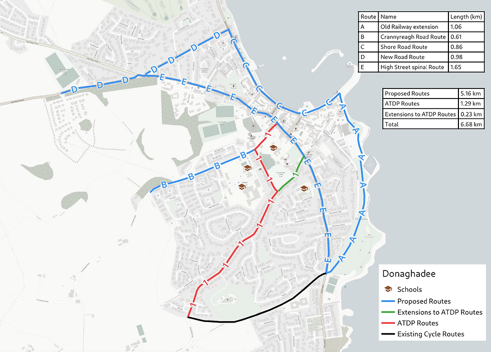
Route 1 links residential areas with schools and the town centre - a welcome proposal.
However, the A2 Millisle Road (only partially shown as Proposed Route E above) is heavily used by leisure cyclists and should be listed as a Priority Route, not a Future Route and extended all the way to Millisle as the 40mph section between Dee and Millisle is windy, narrow and poorly surfaced. Close passes by drivers in a hurry are a daily occurrence on that stretch.
We would also welcome the following additions:
Proposed Route A: this would be a lovely route for young children to learn cycling while their parents walk along.
Proposed Route B (Crannyreagh Road): this leads from the town centre past two schools to the quiet lanes leading into the Ards peninsula.
Proposed Routes C, D and E (ShoreRoad/New Road/High Street) would link up to other sections and provide a circular route around Donaghadee.
Holywood
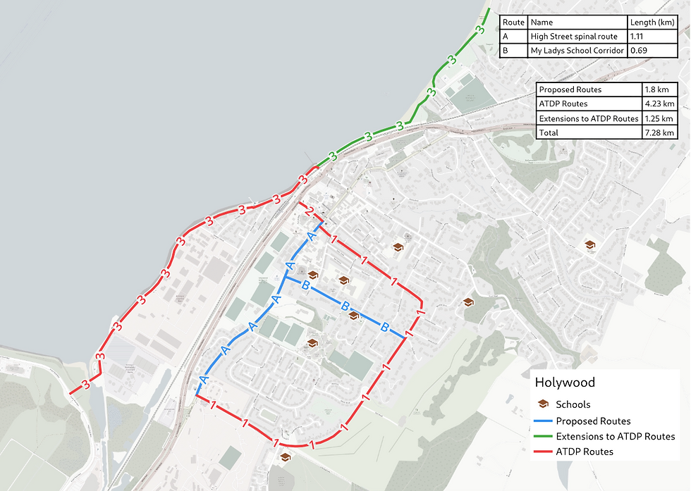
Priority Route 1 should be extended to reach Sullivan Upper School along the length of High Street (Proposed Route A), with a branch (Proposed Route B) leading to St. Patrick's PS. The current plan fails on the objective "Connections to local schools".
Newtownards

The plan for Newtownards presents the most complete hub-and-spoke design in the borough. Unfortunately it omits the provision of safe Active Travel routes from the huge planned residential development south of Movilla Road to the town centre: Bowtown Road should be designated as a Priority Route.
The current plan also neglects to link the under-construction Comber-N'Ards greenway from Floodgates and the Portaferry Road to the Londonderry Park playing fields and the town centre.
Further north there is another missing link (Proposed Route A) where the N'Ards to Bangor greenway will run along Bangor Road. This new sectio of greenway also must be made a Priority Route as it facilitates easy access to Whitespots Country Park.
We would suggest the following amendments to the proposed routes:
Route 1 – link to the Ards/Donaghadee Greenway currently under construction
Route 2 – extend via East Street, Frances Street or Movilla Street to reach the town centre
Route 3 – link to the Comber/ Newtownards Greenway (currently at planning stage)
Route 4 – Extend to Portaferry Road to provide access to playing fields and Floodgates Park
Route 5 – Extend via Frances and East Streets to connect to Route 2
Conclusion:
It is critical that Active Travel routes efficiently and directly connect city and town centres with schools and transport hubs. The current plan does not do that consistently and needs to be revised in consultation with stakeholders, in particular experienced local cyclists and cycle campaign groups.
The proposed plan is under-ambitious as it does not leverage enough of the Active Travel funding available from DfI's annual £800 million budget.
The extensive list of proposed changes above makes one wonder whether anyone from AtkinsRealis Consultants actually visited any of the locations or whether the delivery plan was simply drafted by looking at maps of existing cycling infrastructure. It is concerning that no engagement with local stakeholders took place before the publication of the Delivery Plan. The planning stage could be a lot further along if stakeholder meetings had taken place before rather than after the public consultation. Finally, local residents may wonder why no public consultation had been scheduled for our borough. I wondered the same and asked DfI yesterday. I got an almost immediate response: "We are just finalising the arrangements for the engagement event in Bangor." This morning I received another email: "Further to my e-mail below, I can advise that the event for Bangor will take place as follows: Bangor Castle - Monday 10th February, 2pm – 7pm. That's a good result - well done to DfI and ANDBC!
Please attend in person and provide personal feed-back on the delivery plan if you can.
Comments